LARAPINTA FIRST ATTEMPT.
BEFORE LARAPINTA.
23rd April 2018
What a lovely day yesterday became. After a restful morning which included watching Songs of Praise from Beverley Minister in Yorkshire (a huge church Ruth and I visited a few years ago) we headed off to Sorrento Back Beach for the wedding Bec (Ruth’s Grand-daughter) and Mat. It was a glorious day at the beach and the couple and their guests entered into the occasion with enthusiasm and joy.
Getting home a bit late shortened the sleeping time but we got away early on Monday and were at the airport well before time. Departure was delayed by a Melbourne fog, which we had encountered on the way home last night. Half and hour late leaving.
I had put my navigation watch on the charger before leaving home to get a final boost. I then proceeded to forget it. Hopefully, with Ruth’s assistance and aided by my supply team I will get it by the end of the week.
I meet with Zak from the supply team this afternoon to hand over food supplies and some batteries. They will drop these at three designated spots in the next 18 days.
Studying the maps reveals a varying level of difficulty. Week 2 will the challenging time clambering over razorback peaks and deep gullies to get to good vantage positions. Some days will be steady, others slow some more difficult than others.
My preparation has been going on for several months. My regular walk “around the block” covers 7 kms each time. Then there is the weekly ascent of the 1000 Steps in the Dandenong Ranges which gives a challenging aerobic boost. With the downhill it is equivalent in time to my 7 kms around the block. Part of my preparation was the 60+ kilometre walk down the Overland Track in Tasmania – the surprising roots and rocks trail.
So there is a sense of readiness for the occasion with a determination to be deliberate, careful and anticipation to enjoy the walk in the warm – with the flies.
So sitting here on the Qantas flight to The Alice I have just downed the Honey and Mustard Chicken Ciabata which stimulated the taste buds without really satisfying the hunger it created.
I have a vacant seat beside me and a young fellow by the window. In front, behind and around is a French touring party off to enjoy the pindan red beauty of central Australia, and no doubt will head to Uluru (Ayres Rock) to etch a deep memory of significance in their spirits, especially in the fading twilight.
The power of memory allows experiences to be transformed into the special and any difficulty gets lost in the flashbacks of magnificence.
When we arrived I waited the usual time in front of the carousel before collecting the bag and finding my way to the shuttle into town. My Accor membership had prepared the way with a ground floor room and I quickly settled and unpacked the bag ready for some more inclusions from Alice. My three food bags had arrived by mail as had my little remote switch for the iPhone camera.
Zak from Larapinta Trek Support came around and took me through the re-supply process; three times in the 18 days I will be resupplied with food, batteries and a few other items. He also showed me how to use the tracker, which will follow my progress during my walk.
Then it was down to the shops for a few more purchases to cope with the mozzies and a few other necessities. Back to the Motel for a pre dinner drink and then a monstrous parmiagana. All carbed up for tomorrow. Then it was a matter of finding a way of fitting the new items into the pack and wondering who was going to carry it. Thankfully I can drop of the unwanted at my three supply places.
As it will be hot I have to tank up on water over the next 24 hours. Eight litres plus the tablets to replace salt and energy. Apparently this process over two days helps the body adjust to the reality of walking in the heat.
So, with the air con cooling and in the quiet I am off to sleep. Hope to make an early start after an Ibis breakfast.
LARAPINTA.
24TH April 2018.
Day 1 on the Larapinta.
REFLECTIONS ON TUESDAYS WALK TO WHEREVER
The day began at 5am to follow the preparatory first day pattern. Shower then tape- anti blister: the knees, soles – padding with eye patches, heels and hand that hold the walking stick. Then pack the backpack and strap on the tent and under sheet. Always seems that it is the little things that take the time and first day is always with a little anxiety that it wont all fit in. But it did – again.
Then off to breakfast at the Ibis breakfast bar. Served by a little Asian girl. Seems that the service industry here is well populated by Asian folks. Following breakfast, brush the teeth and wait for the taxi. The start point is about ten kms out of town at the old Telegraph Station. The taxi driver is chatty about tourists and making money and so on. He drops me near the Telegraph Station Information Centre, which is open, but no one is present. And so I wandered around the old stockyards trying to find someone who knew where the Larapinta Trail started but the were all in a morning haze. Down by the Todd River, or in the riverbed, there were cars and swags, an indication that the indigenous community used this area as a dormitory. Turns out it was the Hermensburg mob who had come in for the Anzac Day March. Apparently their horses add a little light horse authenticity to the march. I could see lots of clothing and empty swags. High up the bank was a boot. I came across a lady who didn’t know where the Trailhead was but I was able to tell her where the boot she was looking for. Apparently the dingoes are attracted to the salty sweat in boots and cart them off for a possible meal.
Having done a circle around the Information Centre I found a lady jogger who was able to point me in the right direction. The Larapinta Trail starts at a shelter not far from the Information Centre. It has boards containing information and a signing in book for walkers about to start or end the trail. The Rangers use it for reference if people get in some form of distress.
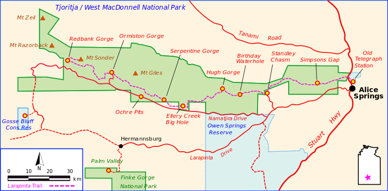
The Alice Springs Telegraph Station is famous for its role in opening up communication across Australia and overseas. It was completed in 1872. As you walk the first part of the trail you come across some poles and wires they have left as a reminder of this communications link.
I set off. The walk, at this stage is not difficult. It takes you through some rises and falls in the countryside with its sparse shrubbery and orange rocks and gritty sand. I was surprised that the bushes, not plentiful but sufficient would often give a semblance of shade to take the pressure off the heat in little pauses. And then on the rises there would sometimes be a little breeze, sufficient to feel its cooling benefit and encouragement to go on.
The first section takes you to Geoff Moss Bridge which is a giant structure spanning the Charles River as its watercourse drifts down from the northwest. Five kilometers have elapsed and progress has been slow as a reminder of weight comes early in the walk and the desire to shed the pack and rest is strong. This I do at the bridge shading in its shadow and as the sun moves it to begin to heat, time to move on.
I find the track as it winds its way northwest to make a crossing of the Ghan railway line. Here I encounter a little shelter before the long hike to the finish at Wallaby Gap another eight kilometers away.
The country undulates but not to great peaks more like small hills. I am constantly looking for boulders to sit on for a rest as the new boots are heavy as is the pack. I keep wondering about the signage and try to contact Zak – my transport provider for some advice. I started off with 5-1/2 litres. At the bridge I had 4 left and so thought I was in reasonable order. But at 2.30pm I was down to 2 litres and concern was emerging. By 5.30pm I still had a litre and a bit so my drinking had been economical in the long section of the afternoon.
I finally reached what I thought was Euro Ridge, one of the marker points. I assumed I was on target as there was a seat at this vantage point. I had been carefully following the map and correlating what I saw, ridges and creek beds with what was on the map. How one can see what one wants to see!!
Only another hour of walking to camp and I covered that quite quickly and still no camp. Then I hit the four-wheel track, which did not appear on the map and thought it was time to summon help. I could not raise Zak so I rang and asked Ruth to try. Maybe there was a problem with my phone. Eventually she made contact and Zak came back to me. He had been out bush with no mobile coverage.
He went to his computer to see what my Tracking device was saying. It is a little sophisticated monitor that sits on the top of my pack and correlates through satellite to Zak’s computer. It was then that Zak discovered that I had missed the walking track at the Bridge and had been following a bike track, as I had sometimes questioned during the afternoon, these bike tracks are now the rage all around the country.
We toyed with the idea of me walking back to the bridge but my small water supply precluded that. Zak then decided to contact the Parks people to work out how to do an extraction that night. He connected with Mark and at about 7.30pm the Hilux emerged out of the bush.
I had put up my tent and laid out my mattress, which were now quickly dismantled and stored in their bag and into the Ute. We were not far out of Alice Springs but too risky to try and walk it. Especially when the track direction would have been unknown to me, and my water supply insignificant for such a task.
The journey back into town took about an hour and a bit.
So ends the first little section. For the rest we will all have to wait.
The Mercure Hotel found me a bed and while the physical recovery was no more than for an average days walk, the mental struggle to understand significance has taken time to lessen.
We will think about what to do next.
LARAPINTA.
25th April, 2018
Paddy Pallin said “You are not lost you are just not where you are meant to be.”
I am back in Alice Springs after being brought in by Parks Ranger Mark and I my Tracking mentor Zac last night.
I started out well at 8am and followed the walking track, which is shared with the mountain bike track. After 5 kilometers the track split only I did not see the split. As I walked the bike track I wondered if I was doing the right thing. Strangely the track I was following looked very much like the track on the map. I have since discovered that what happened was that I made a Parallel Error – one of the most common types of errors in walking. This occurs when you get at least slightly off your intended course and encounter a feature which you then take for a similar feature you expected to see on your intended course.
As my concern grew I tried mobile contact with my tracking mentor at 2.30pm but he was out of phone range. Thankfully phone coverage improved and I was also talking with Ruth and my daughter Margaret. When I finally decided to stop walking I had, shelter, plenty of food but was down to a litre and a half of water. By the time I got Zac at 5.30pm he was able to tell me that my Tracking device was showing on his computer that I was 5 kilometers north of where I was meant to be. Fortunately I was by then on a very rough four-wheel track.
At about 8.30pm Zac and Ranger Mark arrived in a big Hilux. The return trip in the dark was amazing: running board grass in the middle of the road, creek gullies and other bouncy gullies and the occasional rock face. I was incredibly fortunate to have the Zak connection as the Tracker I was carrying had immediately pinpointed where I was. Ranger Mark will put in a report so I will not comment from my perspective at this point of time.
Zak told me that I am not the first to go down that pathway. Such is the risk of solo, multi day walking treks. Obviously I need to learn a few more tricks before attempting another such epic. Those on guided tours will not face such risks.
I am back in Alice Springs discerning what to do next. Ego damage is the only injury.
Barbara Claypole White.
“You’re never truly lost if someone cares enough to come and find you. Lost is waiting to be found.”
LARAPINTA.
27th April, 2018
Hi Folks.
Well what an interesting week. I did get to put my tent up in the bush before being “rescued” on Tuesday night. I came back into Alice Springs with Ranger Mark and Mentor Zac. I have been at the Mercure Motel for Wednesday and Thursday and today I fly out to Melbourne. Whilst my “lostness” was only a few kms out of the city it posed many questions, which I cannot answer at this stage and so I will retreat and think. Much advice has been offered and I will take it into account and work out what to do next.
It has been an interesting experience in Alice Springs. This morning I returned a hire car, which I took out yesterday. As I was walking back to the motel I was captured by the beauty of the gums along the Todd River bed and the gentle cool breeze, which has captured people’s love for thousands of years. I begin to see the beauty and purpose of places like this surrounded by the magic of the hills with their red, orange and purple mix standing on the fringe and seemingly circling the communities within with a forum of magic and mystery.
I had coffee with my dear friends Laurel and Charles Butcher at the lovely bush garden on the Eastside. One can begin to understand the comfort which people experience in this place they call home.
Anzac Day came and went with indecision and it was not until yesterday that I decided to not get back on the horse, just yet. Conversations with those who know have given me some leads to follow to improve various aspects of my experience, which may permit a more qualified approach to this task.
I met with my mentor Zak yesterday who offered continuing support and that may happen one day. I think both of us learnt from the experience. He told me that he took 5 people off the track yesterday, people were finding it somewhat difficult and have decided that is enough. Might be something in the water or not enough water. Tanking up seems to be an important factor in walking up here.
Meanwhile the Mercure has looked after me quite well, while diminishing my reserves. If nothing else, it has been a nice holiday in the centre.
Yesterday I took the hire car out to the Geoff Moss Bridge to nut out where it went wrong. I found a pointing sign, quite low, which I should have found with more care. Not until I went up on the bridge could I see the right track from on high.
I also went to where a track crossed the railway line and found the sign, which I followed which had a small bike painted on it. Thinking back I probably thought it indicated a dual track for cyclists and walkers. I will have a look at my photos later to see if sign discrimination at the beginning of the track is fully helpful. Later I went out to Simpson’s Gap and was impressed by one of the north’ rock and water marvels. It also gave me opportunity to check out a trail campsite, which looked adequate and fairly new.
So here we go with Qantas. If the emails start reappearing you will know “he’s back”.
LARAPINTA SECOND ATTEMPT. 69.6
LARAPINTA. Wombat Gap to Simpsons Gap 10.8
18th July 2018
Yesterday in Alice Springs was spent gathering remaining supplies including gas for cooking. A pleasant meal at the Barramundi Restaurant was complemented with a What’s App conversation with Margy who was waiting for a bus at Lyon in France to take her to Annecy where she will spend time with a girl friend.
Awake at 5am gave chance to cram everything into the bag and race for breakfast at the dining room. The taxi came at 7.20am to take me out along the Larapinta Drive to the gate, which protects a track leading up to the Larapinta Trail.
The driver dropped me off and I walked the 4 kilometers up to the Wombat Gap campsite where I did not arrive in April. I then began my long journey along the 10.9 kilometers to Simpsons Gap. I trundled along the track with its undulations and was travelling well. Past Bloodwood Flat and Scorpion Pool. Lunched near the latter and pressed on to Fairy Springs. The ascending began up to 600 metres over about 5 kilometers. We skirted about half way up the Rungutjirba Ridges drawing near to Hat Hill Saddle. Sometimes the climbs were gradual while at other times they were immediate and demanding.
This is the nature of this track. While some will be on flatland the most of the track will be halfway up one hill or another going up to the end of a gully and back again on the other side. The afternoon stretched out with the regular rests and I finally arrived at Simpsons Gap at about 5pm. A long day.
Along the way I met a guy travelling east who was hoping to reach Alice Springs that night. Two young women were a bit more patient and intended to stay at Wombat Gap that same night.
The scenery around the ridge was magnificent. The Heavitree Range was in the south and the western edge of the MacDonnell’s was in front. All with their ochre and blue and grey painting a magnificent outlook. The day was warmish but the sun was in the far north and I caught shade from the occasional bush. When climbing I was on the shadow side of the hills so it was relatively cool.
Tomorrow I press on to Mulga Camp about 16 kms away. My company tonight tells me that the track is not easy so some exercise is in front of me.
Sleeping tonight in a recently built Parks shelter. Will skip the tent – save repacking in the morning.
Go well.
Peter.
LARAPINTA DAY. Simpsons Gap to Mulga Camp 16.4
19th July, 2018
Today I walked from Simpsons Gap to Mulga Camp some 16 kilometers, one of the longest and “easiest” section of the track. The track followed under the Rungutjirba Ridges to the Arenge Bluff and on to the Tjoroitja/West MacDonnell National Park. It was another undulating path passing through plains and rises breaking into the Bond Gap a little waterhole for wild horses and whatever else drank from it. We rose to a high peak of about 600 metres then descended and further ascended towards Mulga Camp. Each significant rise splashed the beautiful ochre colour from its mountainside and left a sense of awe and wonder. I enjoy just sitting and looking or even better lying on the cooling rocks and feel a sense of tranquility only to be reminded that walking is the way to get there.
Today I passed two fellows walking together and an encouraging lady at Bond Gap. Bond Gap was a quiet little crevice niche into the rock face and dotted with river gums and bushes. Another sedentary repose for local wildlife.
Finally I reached Mulga Camp which consisted of: a modern self composting toilet – they all have them equipped with big round toilet rolls and cleaning equipment – which you are asked to use – on the toilet. There are several tables and a half dozen sleeping pads softened with granulated stove like a mini putting green.
Two young ladies were present but wanting to sleep so we chatted the next morning. Unless you get there mid afternoon there is little opportunity for conversation as we all have our household duties to do before it gets dark. No sleeping deck here.
My little MSR one-man tent is a enclave in such places. Once zipped up there is a sense of security, protected by a layer of rayon or whatever. As the dingoes love the taste of salt it is necessary to sleep with your boots in your tent.
Night comes as does sleep, not unusual to nod off before eight pm as five or six comes around quickly.
Go well, Peter.
LARAPINTA DAY. Mulga Camp to Jay Creek 9.8
20th July, 2018
Today is a relatively short walk to Jay Creek, which is neatly wedged in between the Old Hamilton Downs Homestead and the Iwupataka Aboriginal Lands Trust Property. It is a series of steady rises and falls which tests resolve as one longs for the flatland Karri pathways with their bouncy needle fronds underfeet and their even pathway over distance. But here is the Larapinta rising and falling with the advantage that it rises high enough for Internet connection and a rare conversation with Ruth. Again there is a mystery and mystique in this countryside. The pointy spinifex and the buffel grass on the high rises with occasional shrubby mulga give temporary shade. Eventually I reach the well-appointed Parks shelter and find a midwife from South Australia and a backpacker guy from Utah. Fascinating conversations ensued with each contributing from their varied experience. One talk was about how hungry we did not feel on the walk. A strange experience. The other two retreated to their tents, I used the shelter without tent and felt the coldness in the early morning.
Kathy was going east and Hugh left before me for Standley Chasm. I have not seen him again.
Go well, Peter
LARAPINTA DAY. Jay Creek to Miller’s Flat. 8.6
21st July 2018
The walk from Jay Creek to Standley Chasm was to take seven hours for the best of walkers. 13.4 kilometers in length it is reputed to be the toughest walk on the Trail.
I set off just after 8am and immediately descended into creek bed sand, which I walked for about 1.8 kilometers. An arduous start for the day. Nevertheless there was a sense of power as cliffs and gnarly trees on the banks overshadowed me. Occasionally huge boulders needed to be clambered over but eventually we reached the Fish Hole waterhole. Not through but to the side, up a little bit then the mountain goat path out of the chasm took me to a peak. The view was splendid and the day was still young. Then the rigor began. Into a series of boulder strewn creeks demanding logic and patience, as my pace was very slow. At Tangentyere Junction you could chose the high or low road, I went low when others went high. Not much consolation as it was back to rises and creek beds. Balancing on rocks with a 20 kg pack is no fun as I clambered impatiently through this creek system. At 3pm I was at Millers Flat 8.6 kms into my journey and another 5 kms to Standley Chasm. The access into the Chasm has a fearsome reputation and I calculated I would only make it at great risk – getting in after dark on a treacherous path. I had two litres of water left and some food so I pitched my tent at a little campsite at Milers Flat. I rested beneath this magnificent monolith, part of the high ground that towered above me in all its majesty and beauty. Truly a magnificent place to stop and feel secure in the wonderland of nature.
Sleep came quickly, as did morning. Now the first of my twin fears had to be met. Getting into Standley.
Go well.
Peter
LARAPINTA DAY. Millers Flat to Standley Chasm 5 kms.
22nd July, 2018
With a sense of hesitation I began to pack. Better to stay here in this lovely environment. But to run out of water and to starve, the options were plain. Many times today I felt that the 5+ kilometers were a bridge to far but I eventually got there.
I started back in the creek bed with its never-ending boulders broken by the occasional sojourn on the smoother bank but not for long. The way was slow and extremely painful. Water began to dwindle so I found the outlet of one of many springs flowing into the creek. I disturbed the outlet that the animals did not seem to have found and created a small pool. I slowly filled one of my one litre water containers and then used a clean hanky to get rid of the silt. I then put in a purifying tablet and set off for a half an hour while it did it work. I drank the water with the aid of a filtration straw.
I met Billy, a public servant, on a day walk, which was encouraging. She offered to carry my pack despite a bung knee but I decided to do it alone. I came to a 15 metre outcrop in the middle of the creek and wedged my way up along the north side and then crossed the goat track across to the south side. Emerging from this challenge I looked at another goat track up to the peak of Standley Chasm. Gasping and tugging I got there to the top of Gastrolobium Saddle but then there is the downward descent on roughly hewn paths constructed by the Parks people out of flatstone. The peak led to a valley and we came to Angkale Junction where two rivers or creeks meet when it rains. Only an hour to Standley Chasm. What a memory. In order to preserve the sanctity of the Chasm there is a track which goes over two peaks above the canyon rather than through the Chasm. They are treacherous and difficult weaving their way up this 900 metre climb on loose stones and well place flat rocks.
The final descent was joyous but impatient. My water had run out and my sugar levels were low. After being passed by other walkers during these latter stages I trudged the last kilometer to the kiosk. The staff thought I was a rescue effort and offered Gatorade but all I wanted was an Appleteser and a bottle of cold water. I also wanted a steak dinner and fast. They were gracious and helpful and slowly saw me revive from a disheveled collapsing heap into some form of humanity.
They were most gracious and helpful. Thankfully I had time to pitch my tent and get ready for bed. I tried to master the dysfunctional wifi and finally got some gravelled message to Ruth. The promise of a shower was not forthcoming, as it had broken down.
Nevertheless sleep came quite easily.
It was nice this morning to see other walkers departing knowing that I had decided not to press on today. I would take the day off. It will muck up my plans but I needed time to re-group. Resupply my kitchen from the Kiosk – courtesy of my resupply person, Zak from Alice Springs. The next four days will be equally as tough so a rest day was called for.
Go well, Peter.
LARAPINTA 6. A rest day at Standley Chasm Campsite.
23rd July 2018
So today has been gathered around the lovely campgrounds at the Standley Chasm. The Kiosk nestles at the entry of the one-kilometer walk into the majesty of this special place.
People have been coming and going all day. Families, couples, some in the rents vehicles other in their own cars. It is quite an attraction. Tonight it is quieter around the campsite, no fellow walkers. I have cold showered, washed my laundry, spent much time replenishing batteries and getting things in order.
Tomorrow I carry a full pack including an extra 5 litres of water up to Brinkley Bluff. This is one of a number of high rises, which catches the magnificence of the area. Yesterday, despite the pain of clambering up the backside of Standley Chasm there was also the reward of the rugged majesty. The colours were dissipated having lost their ochre charm to be replaced by a whiting of the texture. It reminded me of the hills around southern Tasmania eaten out by toxic fumes. Truly magnificent to catch their scenes in the midst of your own pain of struggling.
A French physiotherapist encouraged me yesterday when he noticed my efforts coming over the mounts into Standley. He told me that he would go back to his older patients and tell them what he had seen in this older man in the climb.
Go well.
Peter.
LARAPINTA 7. Standley Chasm to Brinkley Bluff 9.9 kms
24th July, 25th July, 26th July 2018
Tuesday, Wednesday and Thursday.
Well I am back at the lovely Standley Chasm campsite, as fate would have it. Let me tell you that tale quickly before recounting the event. I reached near the brink of the magnificent Brinkley Bluff on Tuesday night and camped alone on the ledge of that peak. During the night I suffered a serious bout of diahoreah. Speculation on the cause is endless but I only had a few ADM tablets and was about to head into the remotest and least accessible part of the trip. Early the next morning I rang my mentor who suggested I return to Standley Chasm, which I did yesterday. After a difficult return yesterday due to dehydration and heat stress I will go back into Alice Springs today and further recuperate and see what I can salvage out of the rest of my time here.
On Tuesday I left for the great saga up to Brinkley Bluff. It is only ten kilometers away and has a place for tents, no water or other facilities. So it is necessary to load up enough water for the trip up, the night and the trip down the other side. I took nearly 8 litres of water, in itself weighing 8 kilos. I was also resupplied with food at Standley so that was a five-day supply weighing 3 kilos.
The track begins back down the entry road to the Park and immediately takes you into a creek. So you stumble and bounce in the beginning of a climb up this new hill. Lovely gum trees dot the riverbank and its course and it possesses everything but water. After about two kilometers I left the creek bed and began to follow a path taking me to the Brinkley Bluff summit. Clearly in front of you are the rises and falls of the climb to the top. Emerging out of the creek brings you into the presence of the rolling hills and jagged spheres, which compete, for prominence in this arid area. The vegetation looks like preshave stubble, little shrubs rising to chest height struggling in the rocky rubble to be anything more, but nevertheless giving a green tinge to the ochre dominance and the fading grey white contrasting rocks.
It was hard work as the local camel ironically being the heavy load to replenish the beast of burden. There were many stops on rocks or the shedding of the pack and the gasp for ground. l
Laying prostrate in the shade of the tree. I must say I enjoyed the pack less moments rather than the pack-on time. It is a shame that such effort and energy is needed to be able to lay and look at this aura of magnificence which seems to embrace you and provide a wonderland of beauty, of distinctive character – a special marvel. One could lie forever but the task is always to get to…somewhere…to other vistas, other refining and refreshing sights.
Finally, but finally I reached Reveal Saddle and as you round the corner you lose your breath at the beauty and spread before you. The circular experience of nature is overpowering and an apt reward for the effort of being there. A photograph was taken and sent to you, a small slice of the cake, the rest left to your imagination.
My phone twanged with it noise of connection. Height has the advantage of changing the message from “No Service” to one or two or even three bars of reception. I took the opportunity of ringing Ruth who was entertaining Jill and Wendy from our church. It was lovely to share with them something of the joy.
The munch of lunch was finished and the pack restored to its rightful place and the turtle was off again. The map said two down and two up to Brinkley Bluff five kilometers away.
The downs were great, although the downs in their ups, as always become more shale like and rock filled. Stumbles replace steadiness as it seems that the volcanic eruption or whatever spewed forth its greatest obstacles closest to the top.
The walk over shale faces was at times tenuous and dangerous. The passage was eclipsed by a fear of falling and the button on the help beacons would have been useless because every bone in your body would have been broken.
Time moved slowly and I reached the ten kilometers successfully but the camp was over the next saddle and the sun was setting. I decided I would not make the camp area and so I searched for a place I could level for my tent. And ideal spot was found on a ledge overlooking the really deep fall right down to the track I would reach the next day should I survive the next day.
I sat on a rock and juggled the intricate design of my tent into shape, unpacked my bubble mattress and sucked the sleeping bag out of its container. Then in my confined space I juggled gas, stove, pots and pans. Boiled water rehydrated soup and deb potato. Did not fancy more cooked but had some berries and a muesli bar. That would do for the night. I wriggled into bed about seven only to be disturbed by the eruption about nine which would have looked amusing perched on my little ledge viewed only by the dingoes, lizards and the myriad of magnificent stars.
My explosion created concern. There was an immediate need of fluid replacement but I had limited water supply. I pondered this through the night and got some sleep. I thought if I got to the bottom on the other side I could replenish my water supply but then my limited supply of ADM tablets meant that my trip to the remote areas would have been unsupported. I thought I could also walk out to the highway from the next shelter, about 15 kilometers.
At six thirty I rang my mentor who told me the best way out was to go back. I dislike covering old ground but trusted his wisdom. Whichever way, the next day was going to be rough and it would take several days to get strength back again.
So yesterday I repackaged and turned around. Initially I covered the first two kilometers very quickly. But eight to go and the mileage markers became slower in arriving. I had to cover the downs and up I had traversed to get there. Along the way I met and elderly tour group hiking “gold class” daypacks only and a good meal at the end of the day. When I got back to Reveal Saddle- half way – I was, to put it mildly, buggered. I found shelter under some bushes and shed pack and boots and tried to eat. Nothing appealed and then I remembered Kosta’s Greek cheese. Our favourite Deli had vacuumed packed wrapped four chunks of cheese to be spread along the journey. This was a gift from the Greek god Kosta and was lifting. A lovely course salted blend when nibbled felt like life from another world. I had one and a half litres of water left that I could have drunk there and then but still five kilometers to go.
Around me were another group of retired ancients on a day walk to Reveal Saddle who enquired after my welfare. They also offered water.
I pressed on in the rising warmth of the day stopping and lying frequently until the day walkers who were from the Boorandarah Bushwalking Club caught up with about three kms to go. They recognized my growing delirium and when I took my pack off they stood in front of it and insisted it be carried by Glenn an emergency services guy (former policeman) and they filled my water bottle and insisted I drink. They sounded like the old retired priest from “Father Ted” whose one word was “Drink, drink”. We re-entered the creek bed and with very slow paces finally got back to the access road to Standley Chasm.
We came to the Kiosk and I insisted, could do no other, and bought them all a drink with loads of ice. I think I went through about two Appleteaser drinks and several fruit juices all with lots of ice. I gatecrashed their dinner last night and they have been constantly checking on my condition, which is quite encouraging.
Today I am going back into Alice Springs for a night in a bed and a chance to reflect and reconsider. I will probably leave the next section and maybe come in from the end next week. Who knows? Will leave a little bit more living and wondering to be done.
So lots of discoveries in scenery and in people.
I will let you know. Calm throughout, “all will be well” said Julian of Norwich. It was. May it continue to be so.
Peter.
LARAPINTA 8.
27th July, 2018
Friday in Alice Springs.
Hi everybody. I am sitting waiting for my Caesar Salad at the Motel and take this opportunity to fill you in. First of all thank you for the expressions of interest when things were going well. It was fun to share with you the struggles and joys of the journey through Spot Tracking and emails. And your responses were encouraging and I thank you for that.
This is a different track to anything I have encountered previously. Primarily its remote location creates a different type of connectedness with the wider community and I am not sure I have grasped that in full yet. My pattern of taking regular breaks is not possible in the same way on this journey. Also the terrain is rugged to put it mildly. When you start there are granulated grits, which enlarge into rocks, then boulders and cliff faces as you move further into the track. On my last day I was bouncing along the edge of slate forms sticking up out of the earth and viewing the long fall always either side. The ups and downs were not new but the subtle weather certain debilitates you very quickly. I think the difficult terrain over several days; warmer days, the big “d” and then a ten kms walk back without adequate water finally brought it to an end. A lovey young traveller, Elien Hellen from Antwerp in Belgium brought me into Alice Springs on Thursday in her car. She was moving on to Darwin by herself after dropping me in Alice. We had a great conversation about Belgium connecting at points where I had visited: Ypres pursuing grandfather’s war history; Louven where she studies and Ruth and I attended Children’s’ Spiritualty Conferences as well as beautiful Brussels with its unique architecture and lace lined clothing for grandchildren.
I found a place to stay at Ibis and gathered a few supplies with the intention of resuming the Track next Monday. I had made arrangements to be transferred out there in the next few days but during the night I realized that my recovery was going to take longer. This morning I cancelled out with my mentor Zak and his support people in Alice and they will return my supply boxes. He was very generous in his final remarks:
Hi Peter. That’s probably a good idea to finish. You did very well to complete what you did. It’s a great achievement. We’ll organize for your containers to be returned to IBIS today or tomorrow. Zak
My extreme weariness today has confirmed that recovery will take longer than I first thought. I am resting a lot, drinking from my great supply of bottled water and dousing with hydrolytes.
Ruth arrives on Tuesday and I will now sync my activities with her and enjoy being transported around the area instead of waking. We will do a town tour, then a West MacDonnell’s run and finally drive out to Uluru for a few days.
I will see how the recovery goes over the weekend and if things are better may walk backwards over the bit I missed in April. It is about fourteen kms. So if the tracker starts moving again it will be for that short walk.
Thank you again for your loyal support. And thanks to my Apple Magic Keyboard and iPhone, which has allowed these reports to be written, and sent out when possible.
Go well.
Peter
FAREWELL TO LARAPINTA. Geoff Moss Bridge to Wallaby Gap 9.1 kms
4th August, 2018
Hi folks. It is early Saturday morning and instead of waiting for sleep to return I thought I would pen a few memories for you all. Thank you for following another walk and I hope the descriptions have made it worthwhile for you.
It is over a week since I came back from Standley Chasm with my Belgium driver. I found a place to stay at the Ibis where they gave me a nice ground floor room near the main entrance and dining room. They threw in full breakfast for $1 a time and other facilities made it a good place to be. It was about a kilometer from town so I had a nice walk each day, in pleasant weather. It took about six days to recover from the effects of the dehydration just resting and taking lots of fluids and hydrolytes. Yesterday I was ready to walk again with a daypack and did so on the first part of the Larapinta trail, which I missed in April.
The rest time gave me time to explore Alice Springs and it was good to be able to do so. Like many remote towns it has the various populations. The aboriginal community is those who are building lives through work and those who are reliant on welfare provisions. The latter wander around town in a sometimes-noisy manner making them noticeable which inevitably leads to worry and judgment. The working folks tend to be more obscure just going about their lives. They are not as obvious in the service industry though. These jobs seem to be taken by backpackers and immigrants both required doing their time in the bush to qualify for visas. The service industry reminds me of England which would flounder if you took the immigrant population out. There is a strong component of the white community, which works for the government and are part of the transient number who live here. Then there are many local business people and their families.
This is peak tourist time due to the very pleasant weather. Low to mid twenties with coolish nights. A bit of rain last night but not enough to wash gutters.
On Tuesday Ruth negotiated the car to Goodyear Parking near the airport then bussed to the airport and caught the flight to Alice Springs. She is quite adept at doing this by herself after many such experiences. I met her at the airport with the newly acquired hire car which we have until we leave from Uluru (Ayres Rock). We moved to the Mercure Resort with the help of my Accor Plus membership and it has been a very pleasant place to be.
Ruth had two day trips planned and I was able to join her on both.
On Wednesday we went on A Town Like Alice tour around the sights of the town. It took us to: The School of the Air, the Old Telegraph Station, the Flying Doctor Information Centre, The Reptile Centre and finally Sunset on Anzac Hill. We found it an excellent tour and the commentary and experiences were most helpful.
On Thursday we went on the West MacDonnell tour, which covered the places, I was supposed to walk. Over 100 kilometers from Alice Springs. We went to Simpsons Gap and Standley Chasm both of which I managed to get to. It was good for Ruth to be able to walk these places as well, which she did remarkably well. Then on to the Ochre Pits where the indigenous get their colour for their ceremonies, art and other needs. On to Glen Helen Gorge for a lovely lunch provided by the resort and then to Ormiston Gorge to see this magnificent rock Amphitheatre of natural beauty dotted with a little pool shrunk by the dryness of winter.
Back along the track we visited Ellery Big Pool before heading back to town for a 5.30pm conclusion. It was a great day of experiencing the natural wonders of this area without boots!
Yesterday I did my walk from the bridge on the Stuart Highway across the range and up to Euro Ridge (about 700 metres high) and down to Wallaby Gap Campsite. An amazing view from the top. Along the way I was trailed by a young dingo interested in what I was doing and maybe hopeful for food, my boots or me!!
At the Campsite I chatted with a guy of about my age. He was completing the Track for the second time and it was interesting to share experiences. His gear was ultra lighted measuring the contents of his bag down to a fine scale. He also looked a little fitter than I do. He showed me some mobile vision of a two metre python he had encountered along the way. The only snake he has seen in his two journeys.
After chatting with him I walked the four kilometers down to the highway where Ruth picked me up in the car. It had taken about four hours to do the thirteen kilometers on foot carrying only a daypack with Spot Tracker, food, water and first aid kit.
Ruth had kept herself occupied writing cards and doing the washing for us before we had lunch at the lovely Botanic Gardens – a unique setting with their own distinctive plants and organization as you could imagine in this climate.
We had dinner at a local Italian restaurant called Sporties. The Mall was inundated with motorbikes and quad bikes of all shapes and sizes as they are having a big weekend of competitions here in town and in the area.
Today we will tidy up and get ready for our drive out to Uluru. It is over 400 kilometers to Kings Canyon, our first stop and then another 300 to Uluru after that. We are at Uluru for Sunday, Monday and Tuesday nights and Jetstar back to Melbourne on Wednesday.
Hope this is interesting for you.
Go well.
Peter and Ruth.
THIRD ATTEMPT.
Wednesday 29th May, 2019
LARAPINTA.
The winter has descended upon the Northern Territory making it a good time to walk again. Having walked 70 kilometers in two attempts last year I am back again to knock of the remaining 166 kilometers. This track is not without its challenge. I recently walked 175 kilometers of the Great South West Walk but the Larapinta is different. It traverses along the side of the West MacDonnell Ranges meaning that it is very rocky, sometimes full of extreme gradients rising to 1200 metres and often following up or down waterless waterfalls. Distance is measured in time rather than in footsteps. Some days are actually short in distance but rugged slowing the pace considerably.
Today, Wednesday 29th May, I rose early and Ruth drove me out to Tullamarine. She will fill her time with appointments, rehab, birthday celebrations on the 12th June and in the company of family and friends. I have fifteen days to complete the task.
The pack is well loaded up. Food drops will replenish me on day 6 and day 10 with the help of Outback Elite Tours. In the meantime the pack is overloaded especially on those two days stretches when the campsite is without a water supply on the first night. So I will carry up to 10 litres of water for the two days. As the temperature has dropped to around minus on some nights I am also equipped with extra warm clothing including thermals and a space blankets to try and keep warm. I will head for the Lone Dingo in Alice Springs to top up with gas and matches – not permitted on the plane. Fillipo Geralda from Outback Elite is arranging transport to and from the track and will do the food drops as well. Otherwise I am on my own. The Personal Locator Beacon has been primed on the AMSA website with my travel data should authorities need it if I happen to fling the Beacons antenna. My Spot Tracker has been cranky lately and may not give all the information that it can. I expect phone coverage for Day 1 and maybe on some high spots but not much else. The further away from Alice Springs I get the more unlikely that I will have reception.
Australia is portrayed as a red country but that is not always so. Where I am going the red dust will be plentiful as will the other colours of that country. The black dirt of southern Queensland or the white Sandhills of Perth and the grey soils elsewhere are but a few of this rich colourful country. For now it will be red and the few others I can recognize.
So, follow if you will and when you can depend on reception.
A flood of emails may come at various times.
Go well.
Peter.
Thursday 30th May, 2019
LARAPINTA.
I arrived in Alice Springs at midday yesterday and checked in at the Ibis. Elite Outback had left my food drop boxes and now came the shuffle to fill them. I had posted two bags of food – one for each box depending on where I would be in the days ahead. Then I went downtown to the Lone Dingo to get my gas and a few other things. Back to the Motel and the attempt to move all into the boxes or the pack. The pack would carry about 17 kgs as well as up to 10 litres of water. The thought of the weight and the first day climb kept me awake in the early hours.
After a good evening meal and a good breakfast additionally fortified me for the day ahead.
Chris from Outback Elite picked me up at 7.30am and drove me out to the trail just short of Standley Canyon. I considered the weight on my back and figured I could carry it. So off down the burnt out vestiges of what remained of the flora. A fire after Christmas had blackened much of the countryside. The first day and much beyond had been disintegrated. The good part was I knew the track having climbed up to near Brinkley Bluff last year before the diahoreah terminated that effort.
First to negotiate two kms through a creek bed and then a switch to the upward bound track. Steadily I climbed up to Bridal Path lookout but the view was stark given the bushfire damage. Then on through a winding goats track to Reveal Saddle. Here I spent time on the mobile with Ruth and Karel trying to work out the vagueness of my Spot App, which was not working properly. Then on to the hard walking of the afternoon. The track dips twice and then climbs up to Brinkley Bluff. On the plateau there are a series of ups and downs clambering over vertical slate with the end in view but seemingly beyond reach. A group of three, two men and a woman, from Victoria passed me. This was the first contact with them that was to develop into a walking friendship. Finally I took the last steps up to the cairn on Brinkley Bluff to write my name in the records.
A gale was blowing over the Bluff as it had been all day coming up the track. Gust of between 25-30 kph would often roar through the gullies threatening climber and pack. Up on the summit there are a series of tent spaces (no water – no toilet). Most of these campsites are surrounded by a metre high dry stone circular wall. These walls protect the campers from the wind. They are generous provisions of previous campers who over the years, have been adding rocks to build these walls, making their gift to the future. Tea for me was pizza cooked on my new camping cooker plate and aided by the sliced prosciutto provided by Mandy of our local deli at Mt Waverley.
Bed came early, 7pm and sleep after a few chats with Ruth, also sending texts and some photos. 6am would come too early which it did. But some sleep was grasped: fully clothed with the addition of thermal bottoms and top as well as beanie and gloves. My belly got a little cool during the night but was warmed by my two wind jackets. As there were about ten walkers on the Bluff toileting involved a long walk away from the campsite and the use of my little trowel.
Sunset was spectacular as was sunrise, a real privilege to be in a special place at a special time. The water in the spare water bag was used in full and I was left with three spare litres at the end of the next day. It was nice not to have to carry that weight down the mountain
So ends day one on the track. I made it up that terrain with quite a burden. I was quite pleased with the effort. However it has to be repeated on day three and on another day.
Go well.
Peter
Friday the 31st of May, 2019
LARAPINTA.
As dawn breaks on Friday the 31st of May I am perched on this little plateau, which makes Brinkley Bluff on the Larapinta Track in the Northern Territory. The sun is clear and bright in its orange red splendor, which lasts for a few moments before it breaks into the clear light of the day.
By then some of us are busy packing ready for an early departure. The Road Runners next to me have the art of Backpacking Light down to a tee and are off with their minimum load, breakfast in their pockets. It takes me another hour to put all into the pack and lift it onto my back. The challenge of the day is only 9 kilometers but it is demanding nevertheless. It takes me six hours to make the journey largely because of the terrain.
The first task involves ‘jumping off ‘ the cliff face down 300 metres. Not quite but sometimes it feels like it. The Parks people have steadily recreated the tracks by creating zig zags up difficult slopes. Not neat steps or silky pathways but rough-hewn efforts to make the path more manageable. Stones have been repositioned where possible to make steps. Sometimes the sheer terror is only overcome by resilience and determination. The walking stick is helpful but often it is too close to the inside wall. All one can do is cling to the rock face and press on. Eventually the track above becomes greater than the track below and the precipice becomes less daunting. More level ground is reached but we are still 700 metres above sea level. The next task is to climb up to a saddle, which leads to the final descent. This zig zag is less threatening this time but the effort is still demanding. On reaching the top, one is captivated by the immensity of the rock faces, which surround and the fire damage remains but are now starting to dwindle. Below lies an empty river space, some distance away, my next destination. It is minuscule but increases in size as I descend down another zig zag this one not so difficult. The Parks people have used great ingenuity in establishing these tracks keeping them to a reasonable camber. They take you around to the end of a valley rather than across it so delivering you from merciless ups and downs.
Eventually I reached the sandy riverbed to be greeted by my three Victorian fellow travellers who passed me along the way down. It provided a good opportunity for company in this exquisite setting: dry riverbed surrounded by white gums in the centre of Australia. What a marvelous sight and experience. My friends press on and I finish my lunch and follow. Thankfully the track is not in the river but is a pleasant stroll alongside the river for three kilometers to the next campsite. I had thought that I would be camping in the dirt with water only and no toilet but again the Parks people have been active. A lovely six-bed shelter has been built with two water tanks and a toilet. Fortunately we are early and find a space. Two more join us and then another five are consigned to the tent spaces as room in the shelter has disappeared. I share some cheese which sets off a giving trend and I benefit receiving some new batteries for my Spot App.
The shelter provides opportunity for conversations with both my three new friends and two young ladies from Geelong – they are racing in the other direction on the track. Each of us has a story and all of us have advice to give.
So it is now 7.45pm and all are in bed apart from the tent people whose voices I can hear chatting in the night. Tomorrow is another mountain day of only 7 kms but hard work again. It is another water carrying day, as there is no water provision on the mountain. Hopefully I can emulate Thursday’s effort and tanker the aqua up the hill.
I will keep writing in the hope that some magic will flow into my phone and send them off. Must be a mountain somewhere, which provides reception?
Go well.
Peter
Saturday 1st June 2019
LARAPINTA
Last night was spent in the Section 4/5 Junction Shelter provided by Parks NT. There were the couple from Melbourne and a travelling friend who chose to sleep in his tent; there were two young women from Geelong going at breakneck speed from West to East. Late in the afternoon a group of six guys from Canberra joined us and hoisted their tents.
The night was very cold for me and my blow up mattress has developed a leak so it has to be reflated every two hours. Limited tests using water has failed to detect the problem, a pity as I carry a repair kit. My snoring may have caused one to evacuate during the night.
I was up and away after 8am and made steady progress in the first section of 2 kms. Then I was in the beautiful Spencer Gorge with its red wall being highlighted by early morning sunlight. The rocks grew to boulders and clambering over them was not fun. The three Victorians passed me during this time.
On this day I had to carry extra water as our next camp was waterless. The Gorge comes to and end at Rocky Talis and then there was another steep climb up to Windy Saddle. My progress was very slow and it was now early afternoon with some way to go. I had only covered 5 kms in 5 hours. The next challenge was to cross the notorious Razorback. At times perched precariously on a razorback at other times sitting and sliding on my bum to make progress. Finally I was across and the excellent zig zag began to wind me down to Fringe Lily Creek after nearly seven hours of walking. I am sharing the journey with the three from Melbourne who had arrived much earlier. I pitched my tent in the white sand of the Creek and shared the evening meals with the other walkers; I used the water I had been lugging over these hills. Sleep was well enjoyed after such a difficult and arduous day. But the sheer joy of wandering these ways: the red ochre splashed on soil and rock walls, the spindly but beautiful white river gums, swapping story’s while sitting in the creek beds. There was a mystical charm of colours and sounds. Very few sounds of animal life. My friends had taken a side trip to a viewing point and on the way back were challenged by an aggrieved snake 11/2 metres long. It raised itself up, flared its head and sought to strike out unsuccessfully at the passing’s talent. I thought snakes were timid.
Go well.
Peter
Sunday 2nd June, 2019.
LARAPINTA.
I had a good nights sleep in the Fringe Lily Creek bed besides the sheer ochre wall. My mattress kept deflating but resurgent with blowing – so that looks like the pattern. Breakfast was shared in the round with my fellow travellers and my porridge and sultanas went down well followed by my usual mug of tea.
It is always a problem to get away by eight despite being awake and busy since six. All the little things need their place and the pack has to be carefully counterbalanced so as to carry easier.
I set off down the creek bed for Rocky Saddle carrying less weight of water than the previous day. My pack gave me grief before some adjustments. The task was to climb the Saddle, which I did with the aid of the zigzag works of Parks NT. On the summit of the saddle I felt rejuvenated in my enthusiasm after the difficult day yesterday. Around are these splendid monoliths, silent sentinels of rock displaying their bald beauty with characteristic solemnity.
I arrived at the next turn, Hugh Junction where our track met the 4 kilometer Hugh Gorge. Thankfully this Gorge did not hold the terrors of the previous day and we arrived in camp at a reasonable time. A group we had met two nights earlier occupied the Hugh Gorge Shelter but they told me they were moving off. As the three Melbournians pitched their tents I will be on my own in the shelter.
Tomorrow the track flattens out a little and we have a 15.3 kms trip in 5-6 hours to Rocky Gully. Hard to believe it is Sunday. One gets lost in the sheer effort to survive and keep going each day. The sense of achievement is building and the desire to go on grows.
Go well
Peter
Monday 3rd June, 2019.
LARAPINTA.
Today looked harmless a fifteen kms stretch over to Rocky Gully. I started with a leisurely stroll over the rolling hills and “bumpy lowlands”. We catch a glimpse of past and future at Hugh View the Chewing Mountain behind and the Heavitree Range ahead.
My pack is still giving me grief and I paused to repack. The Melbourne three catch me up and give advice about packing packs which is helpful. Hopefully this is the last readjustment. My pack is relatively new and I am still adjusting to a smaller space and lesser capacity in this lighter vehicle.
The beautiful ridges on the other side of Namatjira Drive look like caterpillars in rock form. The Razorback is fading behind. Namatjira colours on the right. A link between the Chewings and Heavitree ranges is this I now walk. The track rolled into Ghost Gum Flat with its great burls protruding from this huge tree. A table provided space for campers, a good space to be had with solitude and byo water. I would love to stay longer, maybe an option in a future re-walk of the trail.
We are now in the lowlands between the two great ranges with the Alice Valley being the chief descriptor of this lower country.
Creeks provide temporary respite but the afternoon stretches out and the new experience of covering flatland walking is tiring. I use a chunking process walking one kilometer at a time followed by a stop. It brings me into Rocky Gully camp late into the afternoon. I see it from a distance and descend into the gully then walk down to the windy setting where toilet and water define the camp. No Shelter her tonight. Tent to be established on the dirt, in the wind. My Melbourne friends are extremely helpful in my setting up process. They were concerned about my slowness and had thought of going out to find me. Sleep comes easily but concern exists about my slowness.
Go well.
Peter
Tuesday 4th June, 2019.
Larapinta.
I left Rocky Gully early and began the 11 kms walk to the Saddle. Again the tedious nature of long distant walking impacted and slowness ensured. I paused on many occasions and rested in a creek-bed under a lovely river gum. Slowly the Saddle distinguished itself more clearly and emerged as a barrier on the track and as a late afternoon challenge.
Crossing the saddle was exhilarating. It presented juggling the pack, demanding balance and carrying at high risk. At your own devices you struggle up and across the goats track on this rock face. I pondered my insanity on several occasions, alone and in danger. The knowledge that others had come this way was reassuring and I walked in their footsteps to safety.
Relief came at the top followed by an easier descent. The track flattened out but there was still distance to be covered. With extremely tired feet there is a struggle to get to camp. A final challenge in a small hill is then followed by rough descent into the Ellery Creek Car Park. Boots off, pot boiled and into the food packs in the Food Drop storage. Much time is taken to sort out needs and what to take and what to leave behind. Bed as soon as possible as 13 kms tomorrow involves work on many rises.
You will have to live with uncorrected errors, shortness and missing episodes.
Done late at night with sleep coming during typing.
Go well.
Peter
Wednesday 5th June, 2019.
LARAPINTA.
Today was a hard day for me. It was only 13 Kms to Serpentine Gorge Campsite but full of challenges. The first seven were up and down largish hills with full pack. I crossed a Stile over a fence which defines the Roulpmaulpma Land Trust Land. It was a hard walk of ups and downs and the path seem to pick the most difficult way forward. The compensation was that in the absolute devastation of the fire some signs of recovery were present.
The geology was fascinating passing through dolomite outcrops which were shaped by some powerful force many years ago. And off to the left the peculiar shape of the mountain range looking like caterpillars. I believe the indigenous folk incorporate these shapes into their various traditions. I was passed by the Gold Class people doing their trip with daypack and provided meals. One of their group runs for the first half hour of the day. Then came a lone female, then a male then my companions from Melbourne now doing day walks, then a Sydney couple – after this I was alone until young bloke came from the other direction.
The phone worked at high points so I had text and talk to Margie. Also chatted with Warwick and Ruth at Trig point while they were having lunch at R.A.C.V Melbourne. The track eventually took me down to the plain with a gentler undulating character. So I then moved quickly to the shelter just after 4pm. I was greeted by the Sydney couple who were lovely company and knew previous walkers from whom I had met on the Bibbulmun.
Evening duties prevailed and I am sleeping in the shelter without a tent. Done it many time before. Exciting day tomorrow. Climb to see the Heavitree Gap. So the journey goes into week two. It is the hardest track I have done. One step – one day at a time.
Go well.
Peter
Thursday 7th June, 2019.
LARAPINTA
Despite being up early I did not get started until 8.45am. My lateness was due to the fact that I went to the Serpentine Gorge for a quick look and then to the car park to start the walk up the hill.
I made good progress up the preparatory slopes leading to the climb. Then began a ascent up to 1100 meters. The track was rugged, risky in parts which but again carefully developed by the Parks people using carefully placed rocks and zig zagging pathways to ease the climb. Eventually I reached the summit.
The next stage was to walk 3 kms over various shaped rocks to the summit.
Again I was slow and I reached the turnoff to Counts Point later than I wanted. I did not have time to go out and back to the Point and be at the next camp before sunset. So I missed the classic view.
Six kilometers down hill through a steep incline recline replaced the uphill steps at the other end. Then there was a steady trundle back to camp. I was greeted by a big crowd of women going east to west. There is a Shelter but spaces have been claimed. I pitch my tent in one of the remaining spaces. The women tell me that two very hard days lie ahead. I try to get all the jobs done including filling all the water containers and worry that I have eight litres of water to carry. Sleep is pressing at 8.41. Gotta go.
Go well.
Peter
Friday 8th June, 2019.
Larapinta
This has been an interesting camp. Many women in camp going east all gung ho for walking. Many were off and away before me, before sunrise – wearing hi viz night stripes and all have bobbing head torches.
I took off about 7.45am and walked until 4pm. The first bit was easy down to Inarlinga Pass but got harder going up a boulder-infested gorge with lots and lots of clambering required. The Gorge lead to a small plain surrounded by crusty old mountains. I turned the corner into a valley. Looking down the valley I could be three saddles across the valley all needing to be crossed. It was warm boring walking. Half way along I was passed by the Melbourne three who told me that they were going past the Gorge and up to the Giles Lookout – and extra hours climb.
Finally the task was done, I reached the campsite and I set up camp in a creek bed at the first campsite at Waterfall Gorge.
I had carried 4 litres of water extra, as it is too isolated for Parks to supply. So here I am at 6.30pm in bed – early rise tomorrow. I am concerned at my aloneness and the low supply of water that I have.
Go well.
Peter
Saturday 9th June, 2019.
LARAPINTA 11.
Yesterday I traversed from Serpentine Dam to Waterfall Gorge. I had chosen the first of two campsites and was, in consequence, alone for the night. There was a real sense of isolation in this locale for the only way in is by foot. No access other than helicopter in case of emergency. So there I was with the dingoes lusting after my boots for the salt necessitating hiding them in my big garbage bag and anchoring that bag to my tent. I had carried an additional four litres of water much to the derision of my fellow walkers. Additional water meant additional weight usually working out to 1 litre = 1 kilogram. I made it late in the afternoon after a long hot day and could have consumed most of the water there and then. But I had to cook, clean teeth and then have enough for the next day. Given what was before me I began to fear that I did not have enough given the long day before me. By using a sipping budgeting system I had 1 inch of water in my water bottle when I arrived at Ormiston. I was on my feet for 11 hours so I was able to survive that drama again. Thankfully that is the end of carrying two days water at a time – having done it three times – that is enough.
Having been altered to the 17 kms journey being a difficult one I planned to rise early my alarm went off at 4am and I was away by 6am. Pre-sunrise light had not appeared and so the first forty minutes was by headlight. Not highly recommended in such difficult conditions. I chatted with people at the second camp and then struggled down a creek bed. Ultimately that track leads to the “up” sign and up I went. This was the third 1000 metre climb in a week. Thankfully the Parks peoples work on zig zagging saved the day although I wonder how much extra distance you cover using such a track. It took over two hours to cover what they profess should take an hour. On the way up I met a team of 5 going down. They had been on the hill for sunrise and were now off to where I had come from. Eventually I reached the top to find myself alone. Other campers had gone on their way down.
What I encountered was an experience of sheer wonder. The Lookout, as it is called is positioned to catch glances in every direction. Backwards to the Chewing Ranges that I had covered in the last week. Sideways to the caterpillar formations, around and before the Heavitree Range and now bulging out of the horizon, the stand alone magnificence of Mt Zonder where I hope to be on Thursday.
One of the descenders told me that once I got to the top it would be all downhill. Not to be. The trail skids along the top through rocks and gullies until it finds the best descending point. An hour was taken up getting there.
And then the descent. First through the rough-hewn path of uneven nature. And then you leave behind the harder work and strike a more even path as it zig zags and winds its way down. Eventually it hours what is called,
“The base of the hill”.
1.9 km climb.
4.7 km descent
8.9 to go.
And not a lot of energy left. I plodded, set goals, sat down, stood up, walked some more, sat down a lot more. There was no inspiration in the surroundings as it was bushfire country. Just blackened earth and black stick trees, if any. It was easy to see the track way into the distance, a clear path in the black desolation. So at about 5pm I arrived after a final struggle along the riverbank with its characteristic trees and white sand. A long day like my early days on the long lengths of the Bibbulmun. But I made it to Ormiston.
My water was low as was my energy so I moved off the track and onto the sealed road and walked into camp. If I fell over I would have a chance of being found.
When I arrive at the end of a walking day I have that bedraggled look. Journalist Michelle Ryan, wrote about it as looking like a near death experience. It evokes compassion in people: some have carried my pack for the last bit, give me analgesics, put up my tent, insist I lay day or sit down, give me water or food.
I am just running on nothing and those of you who walk such arduous trails know the emptiness of ending. We are tired, not happy people who just want to take our boots off and have some packet soup. Then we can do anything!! Like sleep. Then at 3am the next morning the alarm goes off in our heads and we say: “Let me at it again!” Explain such madness?
Three kind souls let me share their tentsite and off I went with my evening preparation. Best thing was a shower and some pancetta from my food drop. I slept with the glorious thought that, although at 3am, my alarm would go off in my head saying, “Go, go, go” I wouldn’t have to, “No,No,No,” all I would need to do is smile and go back to sleep.
Go well all.
Peter
Sunday 10th June, 2019 at Ormiston Gorge.
LARAPINTA.
Today I am writing to you from Ormiston Gorge Kiosk. I had planned this “day off” before embarking on the final three-day walk plus the walk up Mt Zonder.
The place is a buzz as it is a long weekend in N.T and people are here with the vans and other accommodation as well as day-trippers. The Gorge is a remarkable piece of nature with its extravagant water and its colourful and rugged surrounds.
My three Melbourne walking companions were here overnight and their “chauffeur” one of the wives, shared some of the home made cheesecake she had prepared. They graciously sought me out this morning before they left to say goodbye, such has been the bonds we developed and I know a relief to some of you that I was not alone out here. They will finish more quickly than I and so the farewell was appropriate. They kindly shared some camp cheesecake which was delicious in its making and in its setting.
It was lovely to stand under a hot shower last night and have several attempts to get the stubble of my face. I got my washing done this morning in the hope that it will dry and be ready to go in the morning. I have been cruising around the Kiosk since it opened at 10am and will see them before they close at 4pm for my final Latte, jam cream and scones and buy a pie for tea. I have sifted through the pack and eliminated a few items, which will go back with the food drop people on Thursday.
The system here is terrific. We are given a key on deposit which opens the door to a storage room packed with boxes of fellow travellers with their food drop supplies. Various companies use the room and it obviously enables many people to do this walk. There are two other food drop places: Standley Chasm and Ellery Creek.
It was a joy to catch up with Zak this morning. He was my mentor on my first and second trip and was highly excited that I had come back and got this far. His company was booked out when I tried to make arrangements so I am working with another group.
I will pull out in the morning for a short section to Finke River trailhead about 9 kms away so an easier day for the restart. This is the weekend of the Finke River Speedtest in the NT. You may catch some vision of it on the telly. A fortnight ago there was an organized event to run parts of the Larapinta Trail.
It is lovely to rest and relax today. Tomorrow will tell if I have been too indulgent.
The high points on the walk have served my messaging well. It has been surprising to get good reception so often. And the recharging points in the Shelters has been a real boon. There are still some high spots to go so you might get this before Friday.
The brevity of my reports was due to not having a sitting position. So I would type lying down in my tent, which meant there were many errors. Sometimes I used the mike on the email script which spells out without any writing being needed. It also meant that I would wake up and try to get something finished.
You may find it interesting that with the provision of more Shelters on the trail has come the provision of those USB charging points. Linked to solar and good batteries it allows people to charge their technology on a regular basis. My four large batteries 20,000 mah have not exercised their full capacity.
50 kms to go – 174 covered so far
Go well. Peter
Monday 11th June, 2019.
LARAPINTA .
Today I left the comfort of Ormiston and hit the track again. A short stint only today to the Finke River shelter. I was able to get away by 7.45am and set a fast pace in the early morning cool. The weather is breaking out of its cold pattern of low temperature in morning and during the day. Today the temperature eventually rose to 28. With this has been the return of the flies who are back in their great swarms. The journey today was over undulating rises with one up to 700 metres.
The Finke and the Ormiston creek form a junction where the Shelter is located.
The river beds are magnificent with their lovely white sand and their river Red Gum. Some of them escaped the bushfire and offer an idyllic setting for camping which a husband and wife from Scone have done tonight. They had just started going West to East. They were a bit short on band aids and tape so I unloaded some of mine as I was near the end of my journey. One other guy, Les, from West Albury kept going west for four kilometres to the Glen Helen Gorge to enjoy a bit of luxury at the bar and dining room. He will rejoin me tomorrow night.
It only took 3 hours to do the 9 kms today so I sheltered from the flies in my tent without the rain top. Caught up on a little sleep as well. Tomorrow I climb to 1000
metres on a more friendly path and go on to complete 15 kms. It will be hot again and fly infested so I am gad it will be over. It is the last difficult day. It is also the final rise before the end so you will probably get this account and two others. Remarkable when I only thought you would get one email before I got home. Thanks to those of you who have tried to keep up and for those of you who have offered words of encouragement in response.
Go well.
Peter
Tuesday 12th June, 2019.
LARAPINTA 14.
Today the task was to walk from the Finke River shelter to Rocky Gap Camp. It was a distance of 15 kilometers. I was up at 5am and packed ready to go by 6.45am as were my friends from Scone going east.
In the early light I tramped across the dry riverbed and huge river gums and began to plod across undulating countryside. The goal was a long hill, 1000 metres high seven kilometers in the distance. On top of the hill was a lookout giving 360 degrees of vision. The trip across the plain was relatively fast but negotiating the hill was another issue. A solo Japanese girl came down the hill and reassured me it was easy. However the difficulty of going up and coming down reminded me that I would need 8 hours to traverse Mt Sonder so I have reluctantly given that idea away.
I will walk part of the mount but not all in symbolic gesture of that bonus part of the track.
The effort in climbing the hill today was indeed rewarded with special views all round. I looked backwards to the Chewing and immediately before us Mt Sonder in all of its magnificence and size. Caught brilliantly by Albert Namatjira for this was his territory and you catch glimpses of his colours from time to time.
Tonight I am in one of the Gaps along the West MacDonnell’s – Rocky Gap, and it is very still after a warm day. The flies have come and gone in their masses annoying then disappearing mainly when the cool wind blows. These three days are hot, in the high twenties this week. So an easy day of walking tomorrow winds it up. Only eleven Kms.
I am in the designated camp area near the water tank. Les is sleeping in the creek out of fond memories with his wife on a previous trip. He has given me some food for I am a bit concerned I may run out over the next two days. He will leave early tomorrow in order to catch up with Zak who will take him back to Alice Springs. He will also contact my carrier to arrange an earlier pickup on Thursday.
Go well.
Peter.
Wednesday 13th of June, 2019.
LARAPINTA.
Tonight I am camped in the sands of the Redbank Gorge. It marks the end of the journey from Alice Springs. The bonus, for the willing is to climb Mt Sonder about a 6-hour return journey. For all sorts of reasons I will not do that. But wait for my provider to take me back to Alice Springs tomorrow. Perhaps a wander down to see the Gorge that they tell me is special.
The walk from Rocky Bar Gap was uneventful. The track was up and down but relatively flat. I left at 7.45am and arrived at midday. I am a bit of a flat track specialist rather than a hill climber!!!!
I was impressed on the way as to the amount of vegetation there is in the dry heart. Substantial trees and groves of bushes are not infrequent. This end of the track is well populated with much flora. I skirted along side of Mt Sonder and was glad to be here.
The creek is filled with all types of groups: school parties, commercial guided groups, individual walkers such as myself , and groups of walkers formed on a friendship basis.
The customary water tank is here but the loo is at the top of a nearby hill. I think people will be looking for some bushes during the night.
Tomorrow I will write a reflective piece. At present I am just glad to be here and glad that I have completed the task. It was hard most of the way and the significant climbs I did were quite amazing seeing what they involved.
I am thankful for the voices in the bush, which I heard quite often. I am not sure what they were. Little sound like human voices with several syllables. May have been branches rubbing together or whatever but I took them to mean that I was not alone. Never alone. Never lonely.
Les from Albury gave me some food last night, as I was getting anxious that I might run short. I don’t think I will but it was good of him to help. When I arrived today one of the tour operators offered to take me to Glen Helen but I had to decline much as I would have like to. Then she said, “What about food? Fruit?” And fronted up with two apple juices, two apples and a big piece of chocolate cake!
Never alone!
Go well.
Peter
THE LARAPINTA TRAIL– A reflection….
The Larapinta Trail runs along the West McDonnell Ranges west of Alice Springs. The Trail starts at the Old Telegraph Station near Alice and concludes at Redbank Gorge some 217 kilometres away. An additional conclusion up Mt Sonder is 15 kilometres.
The Trail is never far from a main highway, Larapinta Way – Red Centre Way. This is important as service roads link the Trail and the Way particularly for the provision of water.
The Trail was well populated in groups and individuals walking the Trail. Some commercial groups offer supported end to end walks, walkers using day packs only with transport to the Trail by “Troopees” minimises carrying and provide meals at camps. Other groups do spot visits to key areas of interest.
Re-provisioning for back packing End to Enders or sectional walkers is offered by several commercial groups who also provide transport to walking start points.
Re-provisioning occurs at Standley Chasm (after six days) Ellerey Creek (after 6 more days) and Ormiston Gorge (after 4 more days) a further 3 days concludes the walk at Redbank Gorge. In three sections it is necessary to carry water for two days – I carried 8 litres for two days. Campsites are generally a days walking apart and are equipped with a water tank and toilet and in some places a shelter which has a sleeping platform for six, storage for food and USB charging points using solar batteries. At Standley Chasm and Ormiston Gorge it is possible to shower and dispose of rubbish.
No charge is made for these provisions.
A minimum monitoring system occurs through a Register of Walkers at Shelters. Parks NT accepts no responsibility for walker safety or surveillance but has been known to participate in extractions. Phone communication is improving but is irregular and unpredictable, accessible from the really high points of the Trail – over 1000 metres happens from end to end.
The countryside is stark and arid. While water exists in rock holes or chasms rivers only flow after extremely heavy rainfall. Empty creek beds are a regular experience. Vegetation is sparse but not uncommon. Red river gums are largish tress and small groves of high bushes are encountered. Rock formations vary in size and type and chunks are encountered regularly on the track. It is not uncommon to walk in rocky ravines, scale cliff faces, encounter smooth tracks, scramble over boulders.
Wild life is rare by not unknown. The huge bushfire in January blackened a lot of countryside after Standley Chasm and may have contributed to animal life diminution.
Small flies are an exception. While the weather was cold there were very few to bother walkers. As soon as the warm weather returned the flies were out in droves. Fly screens were needed as Raid or whatever seemed powerless again the droves. Apparently the dung beetle population is declining and is not around in usual numbers to eat the fly larvae.
The trail is an exploitation of its high places where panoramic views of spectacular formations is a common experience. Many try to camp on high points in order to add sunrise and sunset aura to their experience. The huge valleys offer diverse vistas in rusted reds and Namatjira purples. The high rises give constant access to seeing where one has been and where one is going on a regular basis.
The Trail continually skirts the edge of the Ranges meaning that the paths are cut into the rubble of the mountain. Parks NT has done a brilliant job in providing orderly progression through cleared access ways, carefully constructed steps and their zig zags which makes difficult ascent and descent so much easier.
It took me nineteen days in three attempts to complete the Trail. My progress is notoriously slow and is not a good guide some bounce over two or more sections in one day while I struggle to get to the next water!
My comparison to the six other trails is that it was hard, based on a different equation. On the Bibbulmun difficulty was measured by the length of distance between each Shelter rather than on the terrain. The Larapinta is a hard track, your feet are constantly hitting rock and the climbs- 6 rise up to 1000 metres – are not easy, some precarious.
And yet the beauty encountered is in the sterility of the landscape. Limited rain and rocky soil are not a barrier to growth and the country has its own peculiar touches of life. Various shades of colour are spectacular in their redness of rocks and dirt. The colour of leaves vary in their greenness from the soft of nubile tips to the hard sun pressed foliage. Animal life was sparse. No snakes. No Roos. Some small birds but a major absence. This is probably due to the effects of the recent big fire. I was once followed by a dingo, and crows were around.
Rarely was I alone and some good company was encountered at campsites individuals and couples. It was rare that people would not stop and want to talk with you. There is a real sense of community on the track and a sharing of food, bandaging, information and opinion.
When it comes to opinion it is hard for me to get a handle on some conditions. I found that most people did not want to concede that things were “hard”. Some described sections as easy when I found them most difficult. It may also have been related to their younger age or their experience.
Walking is a self-centred process. You need to get to the next point with maximum enjoyment, non-exhaustive speed and early conclusion. So getting on with the job means you are totally focused and largely oblivious to the wider world. This is different to solitude where there is an intent to be quiet to find refreshment. “Through” walking is not that. It is the intention to eat up the kilometres without being conscious of the pain, which is being endured. It is not a meditative stroll through nature.
The chief advantages are medical. Weight loss being one; a fitter body another. Clearer mind comes but it serves no value if it does not involve the commitment to re-enter the world as a creative, useful benevolent person.
I hope this is helpful and I would be happy to answer question and share my responses in this forum.
Go well.
Peter.
